How Geographers Map the Path of COVID-19
When, where, and how? Geographic information systems (GIS) help scientists track the spread of Coronavirus across the world.
In March 2020, the World Health Organization declared COVID-19 a pandemic. Ever since, understanding the path of the Coronavirus has been important not only for scientists, but also for governments, countries, organizations, and humanity in general. Using evidence of the virus’ path in the past can help us predict spatial patterns in the future.
We know that different types of transportation have accelerated the transmission of the virus. But how exactly? One way to find out is by the application of geographical information systems (GIS).
Generally, GIS methods are used for spatial analyses – among these the analysis of traffic patterns and properties. Methods such as zonal statistics, cluster properties, and stochastic processes, as well as numerical analyses make this research interdisciplinary.
By means of GIS methods, we wanted to learn more about the trajectories of COVID-19, including the beginning of the pandemic and its potential ending. Our study covers the whole world and aims to improve our understanding of the relation between traffic networks and the paths of COVID-19.
More Connections, More of a Risk?
In our analysis, we found a high risk for the virus to spread in airplanes, a medium risk in cars and trains, and the lowest risk on ships. We furthermore conclude that road traffic has more connection points and may thus spread the virus more effectively across the world. The possibility for transmission is lower by means of railway, air, and marine traffic respectively.
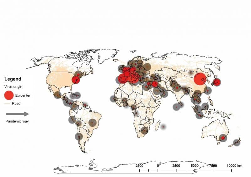
As they are the most connected, we believe that road and railroad traffic could produce new hotspots of coronavirus cases.
Areas, which are densely populated, with lots of traffic connection points have been affected more by COVID-19. Only areas which are not densely populated, with underdeveloped and small traffic networks, as well as isolated island territories have been and will continue to be less affected by the pandemic.
With the increasing vaccination rate stopping or slowing down the effects of the Coronavirus, we expect the elimination of traffic influence on transmission of the disease.
If you are interested, you can learn more here
[Title Image via Getty Images]